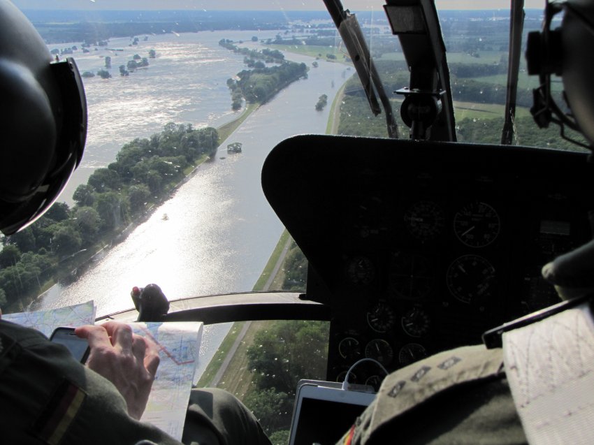
As far as I am concerned this is a perfect illustration of the fact that paper maps have been relegated to being a backup solution for when the battery is empty or the cellular network is down (guess as a helicopter pilot you can’t really afford this). Also amazing how much the military (or paramilitary, not really clear from the picture if this a federal police or an army helicopter) seems to rely on of the shelf consumer technology these days.
[see previous evidence here, here and here]. Over at BLDGblog Geoff Manaugh reflects on a feature in the last edition of WIRED that praises GPS and user generated map files for allowing rich westerners to travel through remote parts of the world (Namibia in this case) without the need for local guides. In ‘the digital replacement of the natives‘ Geoff argues that this trend – should it become more widespread – will probably be devastating for local economies based on tourism:
I can’t help but wonder what this might foretell for local economies based on guided tourism around the world. For instance, a small group of American tourists comes through your village, eating PowerBars and looking at handheld GPS devices. They don’t go to any restaurants; they don’t ask any questions of anyone; perhaps they don’t even rent a hotel room. For all economic purposes, it’s as if they were never there. They were more like surreal poltergeists wearing Vasque boots, reading Jonathan Safran Foer on a Kindle. What better way to avoid meeting Namibians! Just use their electrical grid to recharge your gadgets, pay no taxes, and leave.
I’m left imagining the inverse of this situation, of course, in which a small group of Namibians shows up in London. They ask no questions, eat at no restaurants, and avoid all hotels – before going off to wander round the countryside, sleeping in tents. It would all seem rather mysterious.
‘Mysterious’ is definitely to soft of a term here: in post 9/11 reality ‘mysterious’ is synonymous with ‘suspicious’ which, (especially if you are not white and handle high tech gadgets) is very likely to result in 90 or so days of detention without charge.
I have written about virtues of ‘the knowledge‘ and the dangers of GPS to human evolution before. Now the good old BBC is running an article that actually pits the one versus the other in some kind of technology versus humans death match. They held a race through London in which a cab driver (in possession of ‘the knowledge’) had to compete against a BBC hack who was following the instructions of a Tom Tom GO 720 navigation unit:
We chose waypoints that took us through extremely busy parts of London. We would need to go from Box Hill in Surrey to Wembley Stadium, then the Houses of Parliament and finish at Greenwich Observatory. In fact, if we had just followed the shortest route to our first waypoint – the new Wembley Stadium – we would have gone right through some of the worst traffic blackspots in the area.
The rules were simple. Andy the cabbie could choose whichever route he wanted, listen to traffic reports on the radio, and change route at any time. But so he did not get an unfair advantage, he was not allowed to use bus/taxi lanes to avoid any jams. I had to do what the sat-nav said. No exceptions.
The BBC’s Spencer Kelly won the first part of the race as a result of the GPS suggesting to take the M25 that bypasses London and managed to get to Wembley Stadium 5 minutes ahead of the Cab driver. The second leg, however was clearly won by the Cab driver who proved much more experienced in navigating through the highly congested city center and arrived at the Greenwich Observatory a full 27 minutes before the car following the sat-nav instructions. Guess this illustrates my point that relying on GPS for navigation is definitely going to be detrimental to humankind.
And i mean this literally. I have already written about the degrading orientation skills of London cab drivers, but in the last couple of days i noticed a much more alarming trend. on three occasions i have spotted people using those irritating gps based car navigation units to walk(!) around town. Friggin’ insanity! what do people think they have brains for these days?
First time i noticed this was in the phone shop where two female japanese tourists enquired about the stand alone gps units and bought one although the sales-clerk warned them that it only had map data for the Benelux on it. They replied that they were fine with Amsterdam and Bruxelles and needed nothing else, bought it and left the shop. Then the other day i saw a group of tourists wandering along the canals one of them holding one of these units in his hands. Tonight cycling back form central station i noticed two teenage girls walking along the street both of them staring on the screen one of them was holding one of these devices in her hands:
This time i actually stopped and asked them what they where doing with with that thing. they replied that they used it as a map as they were not form here (obviously! – judging by their accent they came from some Scandinavian country) and that it was in fact much better than a map as they never managed to properly read traditional maps anyway.
I think this fundamentally disturbs me. makes me wonder if people will start removing parts of their brains in order to lose weight. On the bright side this of course points to a much better future for the inhabitants of major touristic hotspots as they won’t be asked for the directions all the time anymore. Thinking of this, this might actually mean that one day in the near future drunken British males will be able to find the amsterdam red light district by themselves…
Ars technica has a sweet little write-up about the fact that London cabbies apparently reject satellite navigation devices (which they are allowed to use since beginning of this year). The main reason seems to be pride in having passed the notoriously difficult exam (‘the knowledge‘) which is required to get a license:
Cabbies have two basic reasons for not embracing the systems, one rooted in technology and the other in psychology. For one thing, the devices still do not give the kind of perfect directions that are needed by someone who makes a living driving a car about the city. But secondly, the devices also remove the mystique that surrounds the Knowledge and the pride that passing the exam gives to cabbies. With a satellite navigation unit, just about anyone can become a cabbie and they can do it without studying.
Now everybody who was forced to take a cab in Amsterdam in the last couple of years will be able to attest to the fact that it is indeed a very bad idea if (a) ‘just about anyone’ can become a cabbie and (b) they do rely on satellite navigation which does not work in congested European city centers. Kind of surprising to see that that conservative stubbornness of the islanders does have positive effects once in a while…
meanwhile... is the personal weblog of Paul Keller. I am currently policy director at Open Future and President of the COMMUNIA Association for the Public Domain. This weblog is largely inactive but contains an archive of posts (mixing both work and personal) going back to 2005.