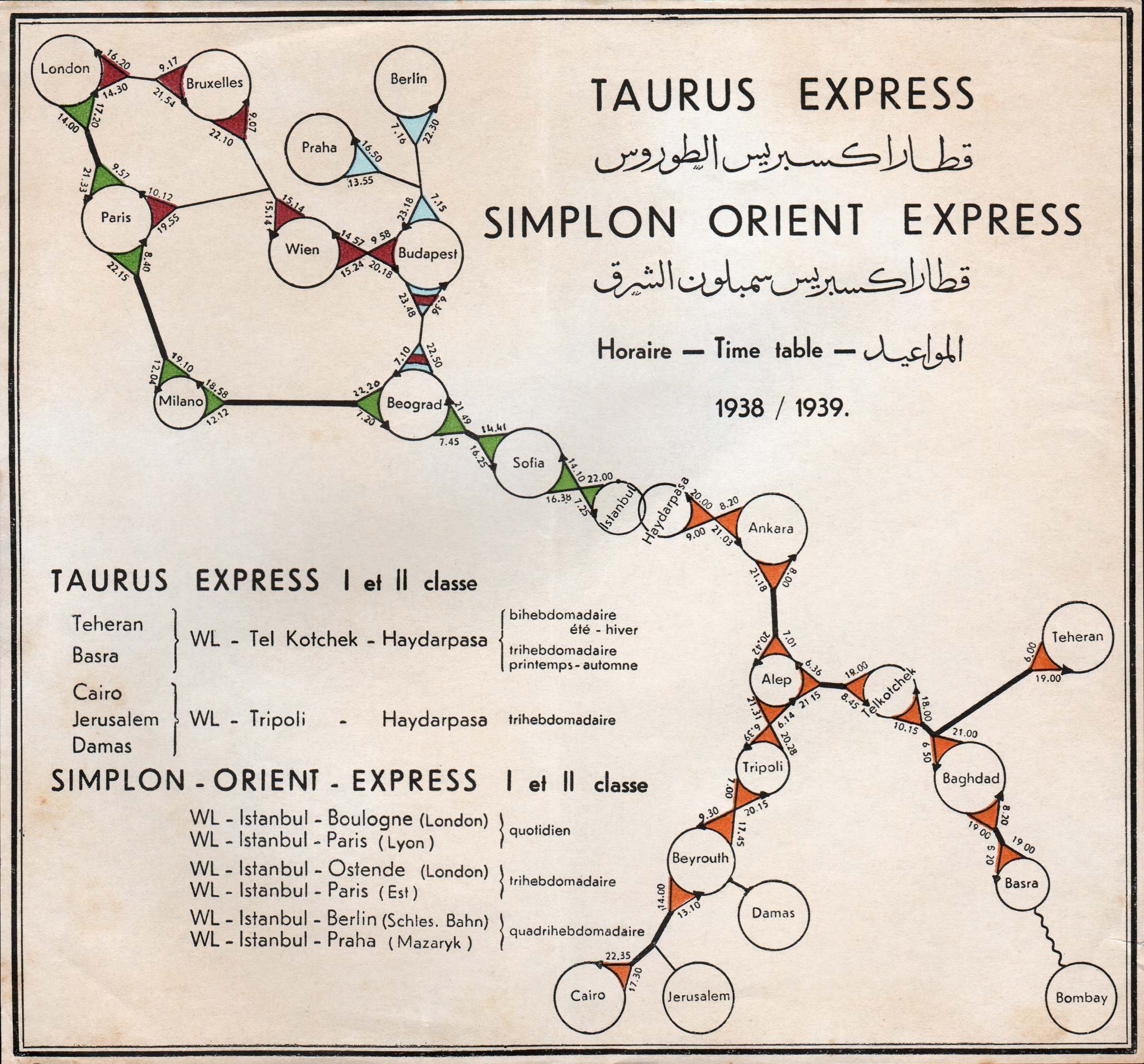
Speaking about railway nostalgia, I came across this illustration on flickr today, which illustrates the networks serverd by the TEE predecessor Simplon Orinet Express and its middle eastern equivalent the Taurus Express in the late 1930s:
Taurus Express and Simplon Orient Express via Bruce Sterling's flickr
If there is talk about reviving old railway networks then we should probably skip the TEE and go right here. If revieved, this network would cover more than enough of the world for me to never set foot into an airplane again and spend the rest of my life exploring these parts (as of writing i have visited or lived in 9/11 of the stops on the European side of this network and 7/13 on the Afrian/Asian side).
So today the dutch railways (NS) ran a one-time Amsterdam Berlin intercity service that was 27 minutes faster than the usual 6 hour 30 minutes Amsterdam Berlin intercity service. They achieved this by omitting all stops between Amsterdam and the German border (Hilversum, Amsersfoort, Apeldoorn, Deventer, Amelo and Henglo). According to the NS it should be possible to further reduce travel time to four hours by aquiring engines that are capable of running 200 km/h on the Dutch and the German railwys (right now there is a change of engine in Bad Bentheim that takes about 15 minutes) and by skipping most stops on the German side (Bad Bentheim, Rheine, Bad Oeynhausen, Minden, Wolfsburg, Stendal and Berlin Spandau). The main obstacle against this badly needed upgrade of the Amsterdam Service? According to the Volkskrant all these little places insist on having the train stop in their stations.
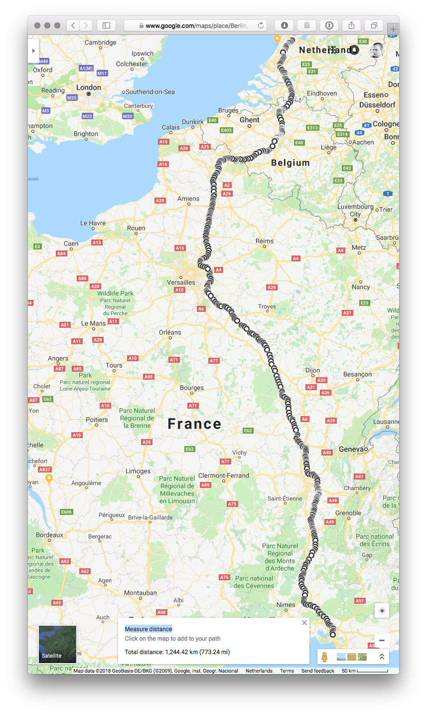
Still the NS seems to be fairly determined to upgrade the line and bring the travel time down to four hours1, which would make it roughly competetive with direct flights between Amsterdam and Berlin. Four hours between Amsterdam and Berlin would mean an average speed of 160 km/h which is nice compared to the current average of 98 km/h but it is a far cry from the 200 km/h reuired to qualify as a high speed rail service. By comparison i have recently had the pleasure to travel on the so called Zon Thlays (a dedicated summer weekend only service that connects Amsterdam with the south of France) which runs the 1244 km from Amsterdam to Aix en Provence in 6 hours 47 minutes (an average speed of 187 km/h including a 15 minute crew rest stop at Paris CDG Airport, required by labour regulations). This is nearly twice as fast and makes the 6 and a half our drudgery of the current Amsterdam Berlin service even more unbearable. It brings Marseille within 7 hours of Amsterdam which feels quite amazing in more than one way (both of them being old port cities on opposite sides of the continental European land mass that culturally feel much further apart that a 7 hour train ride).
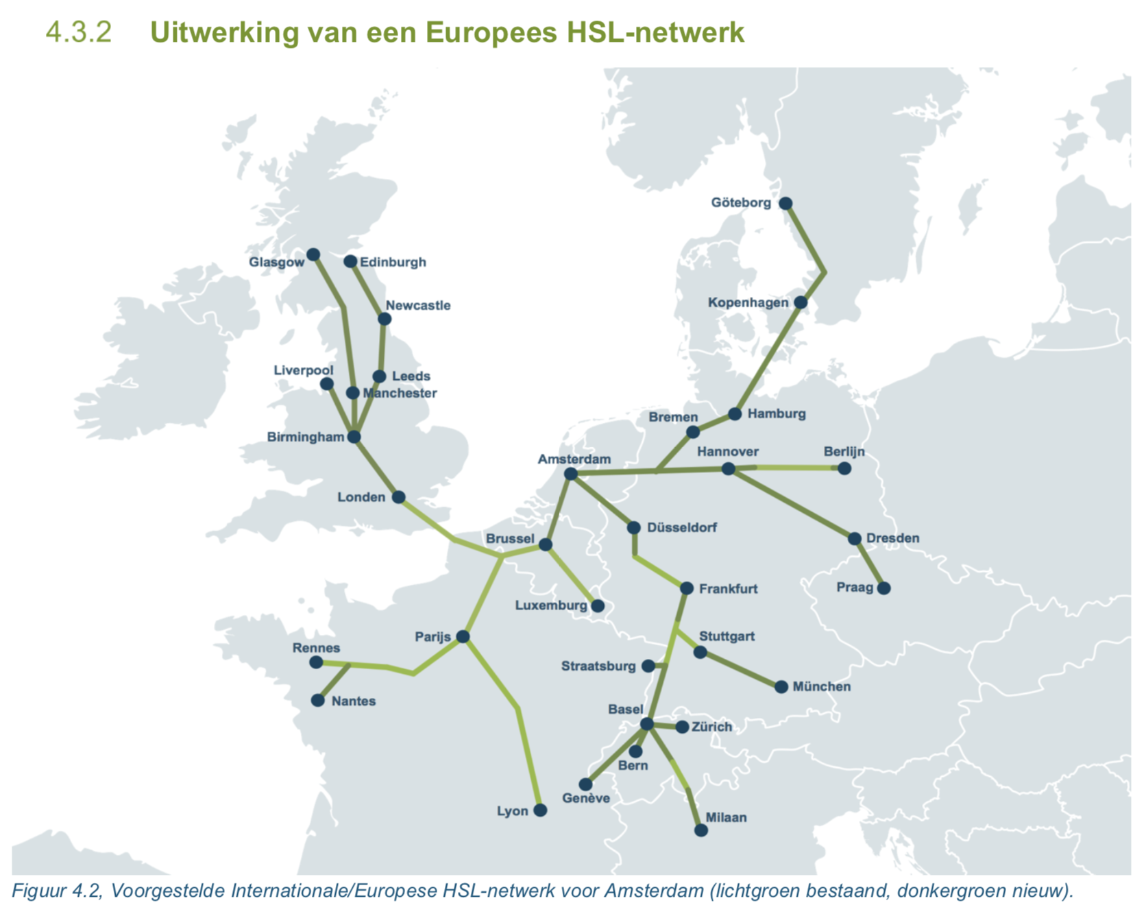
Now most of the service runs on dedicated high speed lines (with the notable exception of the bit between Antwerp and Brussels which the Belginas refuse to upgrade, in their own petty version of the i-want-the-train-to-slow-down-and-call in-my-little-village described above) and it does not make any sheduled stops between Brussels and Valence, bypassing Paris to the east (see routemap below). The trip feels like a triumph of infrastructure over time and it illustrates that if we ever want to get Euroepans of their addiction to low cost flights we will need to substantially invest into better high speed rail infrastructure.
There is no good reason why people should be able to fly across the continet, destroying the climate in pursuit of the next city trip if we had infrastuctire linking major cities that would allow travelling 1200 km or so within 6 hours (think breakfast in Amsterdam, dinner in Marseille). Now such infrastructure does not come cheap2, but given the climate destroying effects of our addiction to cheap short haul air travel, there are little alternatives.
The most logical source of the required investments would be a suracharge on intra EU airline tickets. A modest €20 per ticket would bring in €12,5 billion per year (based on the 626 million passengers of national and intra EU28 passengers identified in the 2016 air transport statistics). To make the point that people should take the train insteard of the plane it this surcharge should be inreased to €100 per ticket for routes that compete with trains services that take 4 hours or less such as Amsterdam-Paris (1,26M passengers in 2017 = €101M extra ), Paris-London (1,07M passengers in 2017 = €86M extra) and many others. Over time such surcharges could result in substantial funds that can be invested into building a better high speed train infrastructure (think Japan) and in the short run they would make train operators on existing high speed connections much more competetive.
Given the political clout that the airline business has (they have succesfully resited the idea of taxing jetfuel for decades) such a measure would require a lot of political will to enact, but given the untenable trajectory that we are on when it comes to airtravel, there may be little other choices. The only other alternative would be for people to actually travel less. While undoubtably better, it is quite a hard sell on generations raised on cheap jet-fuel and the idea that multiple city trips per year are a basic human right.
Route of the direct Thalys service from Amsterdam to Aix en Provence
Which is probably an unrealistic excpection. This 2018 study by engeneering firm Royal HaskoningDSV (commissioned by Natuur en Milieufederatie Noord-Holland) comes to the conclusion that without upgrading the track the measures described above would result in a retuction of travel time of 46 minutes only (page 32). This would mean five hours and 38 minutes total travel time which is not much better than the current situation. The same study calculates that upgrading the route to proper high speed infrastructue would reduce total travel time time to 3 hours and 4 minutes (page 36, note that this tiem includes transfer to and from the train station) ↩︎
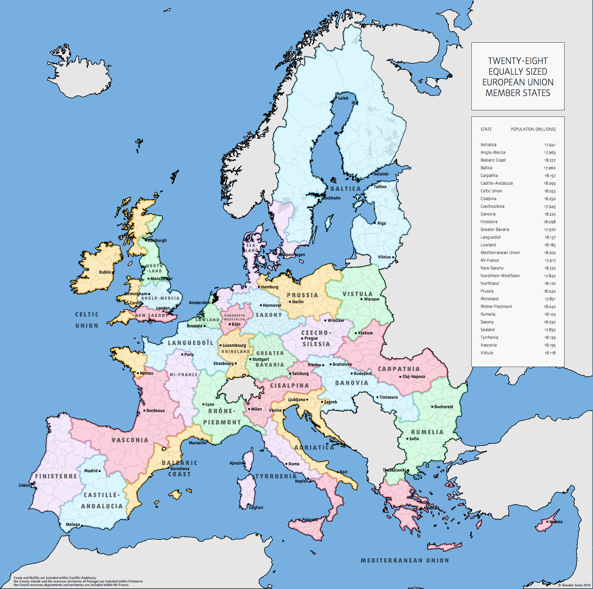
I am strangely fascinated by this map that depicts the European Union as 28 equipopulous member states (although i would rather imagine this as administrative territories rather than as states):
Equipopulous Europe by Alasdair Gunn
Twenty-eight equally sized European Union Member States, by Alasdair Gunn
Of course this is utterly unrealistic as (re)drawing borders has been one of the most destructive activities in the history of humanity. So the only way to improve on the current situation would be to do away with border altogether.
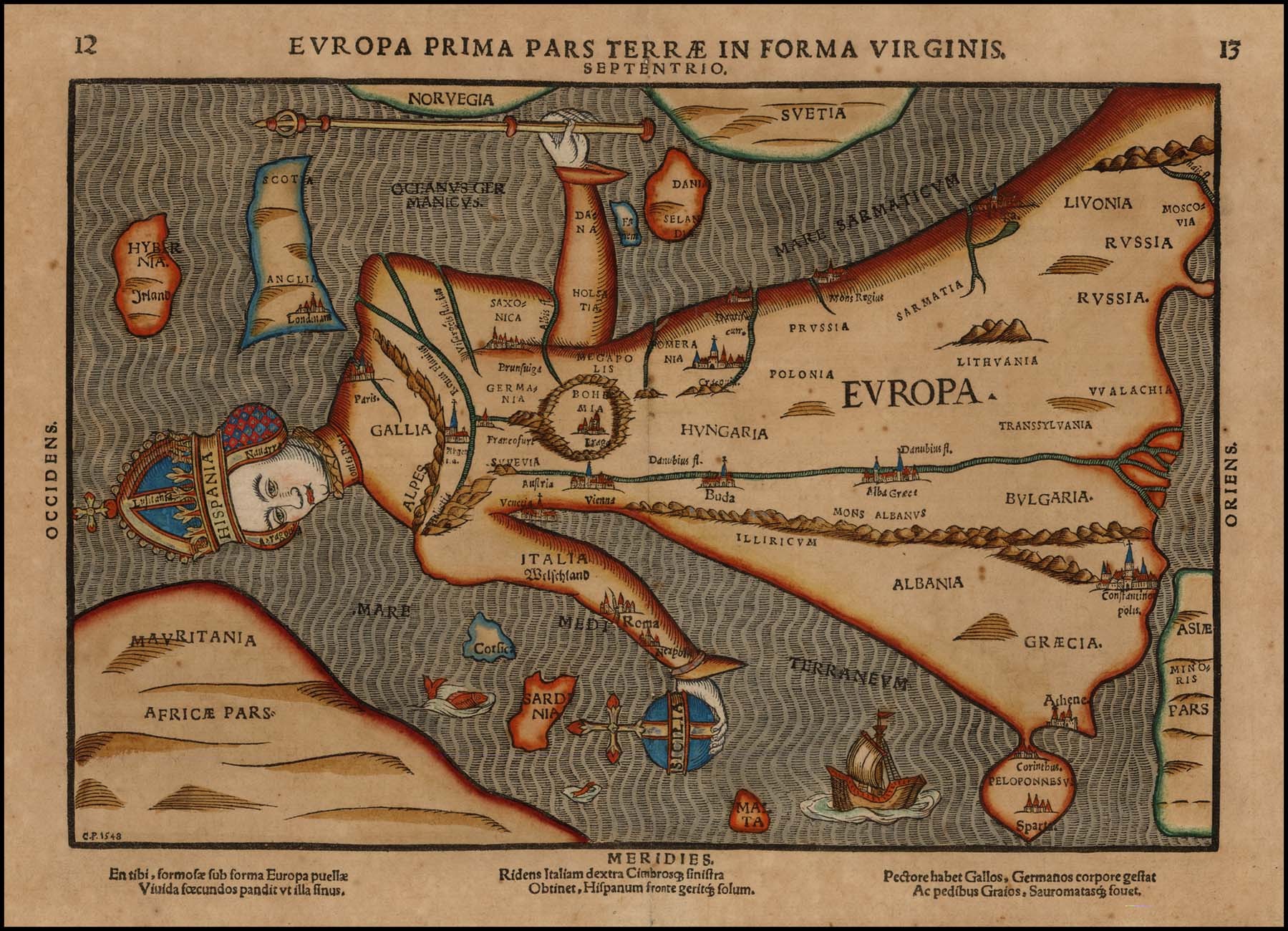
Europa Prima Pars Terrae in Forma Virginis (1582) by Heinrich Bünting
Found this in yesterdays newspaper, next to an article comparing the current state of the European Union to the state of the Habsburg Empire right before its collapse. Not sure about that comparison, but the map is amazing.
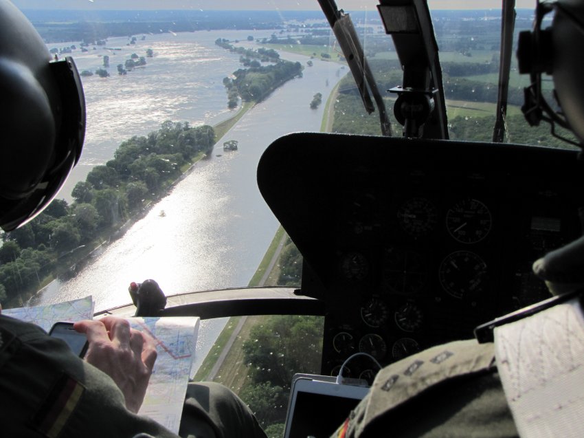
As far as I am concerned this is a perfect illustration of the fact that paper maps have been relegated to being a backup solution for when the battery is empty or the cellular network is down (guess as a helicopter pilot you can’t really afford this). Also amazing how much the military (or paramilitary, not really clear from the picture if this a federal police or an army helicopter) seems to rely on of the shelf consumer technology these days.
Had to take a leak yesterday as we were on the way back from the opening reception of the uitmarkt on java island. conveniently we were cycling past the navy terrain in central amsterdam and the outside wall of this super secret military installation is about the only place in all of central amsterdam where you can actually take a leak a little bit off the road. turns out that it is not only a very convenient place but probably also the most private place to take a leak as you are protected from a satellite picture of yourself showing up on google earth/maps:
Of course you are probably still being filmed by all kinds of CCTV installations and if you are really unlucky you will get caught by one of the google street view cars that are currently roaming the streets.
[see previous evidence here, here and here]. Over at BLDGblog Geoff Manaugh reflects on a feature in the last edition of WIRED that praises GPS and user generated map files for allowing rich westerners to travel through remote parts of the world (Namibia in this case) without the need for local guides. In ‘the digital replacement of the natives‘ Geoff argues that this trend – should it become more widespread – will probably be devastating for local economies based on tourism:
I can’t help but wonder what this might foretell for local economies based on guided tourism around the world. For instance, a small group of American tourists comes through your village, eating PowerBars and looking at handheld GPS devices. They don’t go to any restaurants; they don’t ask any questions of anyone; perhaps they don’t even rent a hotel room. For all economic purposes, it’s as if they were never there. They were more like surreal poltergeists wearing Vasque boots, reading Jonathan Safran Foer on a Kindle. What better way to avoid meeting Namibians! Just use their electrical grid to recharge your gadgets, pay no taxes, and leave.
I’m left imagining the inverse of this situation, of course, in which a small group of Namibians shows up in London. They ask no questions, eat at no restaurants, and avoid all hotels – before going off to wander round the countryside, sleeping in tents. It would all seem rather mysterious.
‘Mysterious’ is definitely to soft of a term here: in post 9/11 reality ‘mysterious’ is synonymous with ‘suspicious’ which, (especially if you are not white and handle high tech gadgets) is very likely to result in 90 or so days of detention without charge.
So 2007 is coming to an end and it is time to draw up the balance. when it comes to migrants who have died trying to reach Europe, 2007 has been an exceptional bad year even though the powers that be seem to think otherwise. Back in august the IHT quoted spanish and italian officials that proudly proclaimed that the number of arrivals at their shores had been down from the numbers for the same period in 2007:
The deadly flow of flimsy boats crammed with migrants heading north across the Mediterranean has slowed substantially this summer. After years of surging arrivals, Italy and Spain, the initial destinations for thousands fleeing Africa for safety or jobs in Europe, are reporting drops of a third or more compared with last year.
Government officials in both countries trumpet success from more sea-borne patrols and better cooperation with African nations across the Mediterranean to reduce journeys that have seen often-unwanted migrants wash up in Europe and claimed thousands of lives in the past decade, experts estimate.
But even as Spain is reporting a sizable decrease in drownings, success is far from complete. With more obstacles in place, migrants appear to be taking greater risks. Fortress Europe, a migrant advocacy group, reports that the number of deaths among those seeking to reach Italy has remained stable, despite the drop this year in overall arrivals, suggesting that those who try face a more perilous journey.
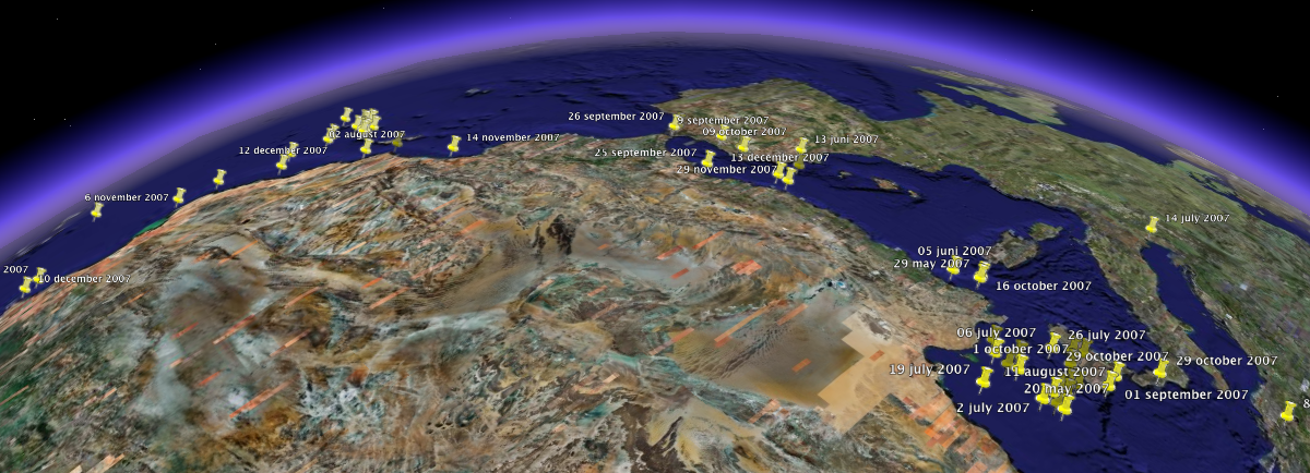
Looking at my own figures i can only second this impression given by Gabriele del Grande. 2007 has been worse both in terms of incidents (55 in 2006 compared to 90 in 2007) and the number of victims of the European border regime (653 persons have died trying to reach europe in 2006. 2007 has already cost 730 lives). Of course these numbers do not represent the real tragedies that are taking place as they are derived from those incidents that are reported in the international press and as they only count those who are confirmed to have died (the numbers would quadruple if they would include all those reported to be missing).
While i have seen no year-ed figures for the number of arrivals it seems safe to say that spending money on stupid joint operations and videos aimed at scaring people away does not exactly work as intended. Neither does it keep people from coming to Europe nor does it keep them from dying while trying.
Update 26-12-2007: There is an excellent article (in German) about the same topic and specifically about the questionable role of frontex available on telepolis.
Deadly incidents in the western mediterranean/atlantic in 2007Deadly incidents in the Eastern mediterranean in 2007
I have written about virtues of ‘the knowledge‘ and the dangers of GPS to human evolution before. Now the good old BBC is running an article that actually pits the one versus the other in some kind of technology versus humans death match. They held a race through London in which a cab driver (in possession of ‘the knowledge’) had to compete against a BBC hack who was following the instructions of a Tom Tom GO 720 navigation unit:
We chose waypoints that took us through extremely busy parts of London. We would need to go from Box Hill in Surrey to Wembley Stadium, then the Houses of Parliament and finish at Greenwich Observatory. In fact, if we had just followed the shortest route to our first waypoint – the new Wembley Stadium – we would have gone right through some of the worst traffic blackspots in the area.
The rules were simple. Andy the cabbie could choose whichever route he wanted, listen to traffic reports on the radio, and change route at any time. But so he did not get an unfair advantage, he was not allowed to use bus/taxi lanes to avoid any jams. I had to do what the sat-nav said. No exceptions.
The BBC’s Spencer Kelly won the first part of the race as a result of the GPS suggesting to take the M25 that bypasses London and managed to get to Wembley Stadium 5 minutes ahead of the Cab driver. The second leg, however was clearly won by the Cab driver who proved much more experienced in navigating through the highly congested city center and arrived at the Greenwich Observatory a full 27 minutes before the car following the sat-nav instructions. Guess this illustrates my point that relying on GPS for navigation is definitely going to be detrimental to humankind.
And i mean this literally. I have already written about the degrading orientation skills of London cab drivers, but in the last couple of days i noticed a much more alarming trend. on three occasions i have spotted people using those irritating gps based car navigation units to walk(!) around town. Friggin’ insanity! what do people think they have brains for these days?
First time i noticed this was in the phone shop where two female japanese tourists enquired about the stand alone gps units and bought one although the sales-clerk warned them that it only had map data for the Benelux on it. They replied that they were fine with Amsterdam and Bruxelles and needed nothing else, bought it and left the shop. Then the other day i saw a group of tourists wandering along the canals one of them holding one of these units in his hands. Tonight cycling back form central station i noticed two teenage girls walking along the street both of them staring on the screen one of them was holding one of these devices in her hands:
This time i actually stopped and asked them what they where doing with with that thing. they replied that they used it as a map as they were not form here (obviously! – judging by their accent they came from some Scandinavian country) and that it was in fact much better than a map as they never managed to properly read traditional maps anyway.
I think this fundamentally disturbs me. makes me wonder if people will start removing parts of their brains in order to lose weight. On the bright side this of course points to a much better future for the inhabitants of major touristic hotspots as they won’t be asked for the directions all the time anymore. Thinking of this, this might actually mean that one day in the near future drunken British males will be able to find the amsterdam red light district by themselves…
meanwhile... is the personal weblog of Paul Keller. I am currently policy director at Open Future and President of the COMMUNIA Association for the Public Domain. This weblog is largely inactive but contains an archive of posts (mixing both work and personal) going back to 2005.


 Deadly incidents in the western mediterranean/atlantic in 2007
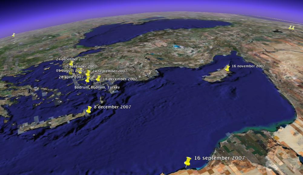 Deadly incidents in the Eastern mediterranean in 2007
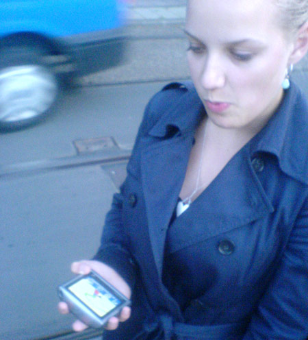