
Mapping dead migrants
Since December 2002 i have been collecting press reports about migrants who have died trying to reach Europe for the noborder website. At the time of writing this the list has grown to 179 incidents with a total of 2009 reported fatalities and an even higher number of people missing who most likely have died as well. It is also safe to assume that the majority of such cases never gets reported in the press at all (according to spanish immigration officials about 6000 African migrants have died or gone missing on the sea journey to the Canary Islands in 2006 alone).
Over the last couple of days i have taken the data i have collected and mapped it onto google earth to get visual representation of the geographic distribution of these incidents. If you have google earth installed (it is a free download from google) you can download the .kml file here (right click to download) and have a look at the data yourself.
The visual representation of the data clearly shows that most migrants perish at sea. there are 4 big clusters of incidents:
One along the west coast of Turkey (mainly boats attempting to reach the Greek islands of Lesvos, Chios and Samos from the region around Izmir). The second cluster is along the route from Libya and Tunisia to Sicily, Lampedusa & Malta (the data for 2005 actually looks like a straight line from Libya to Sicily). The third cluster is around the strait of Gibraltar and the last cluster of drownings can be found along the West African coastline (boats from southern Morocco, Mauritania & Senegal attempting to reach the Spanish Canary Islands.
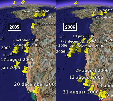
This last route has become especially popular (and deadly) in 2006: in 2003 5 incidents were reported around the Canary Islands, in 2004 there were 7, in 2005 9 and in 2006 the number soared to 23 reported incidents. This increase is commonly attributed to the fact that straight of Gibraltar and the Moroccan coast have become more heavily policed by European and Moroccan police and military forces so that sub-saharan migrants are forced to find alternative routes to Europe. One of these routes is the up to 1500 kilometer long voyage across the open Atlantic ocean from Mauritania and Senegal to the Canary islands which are part of the EU. The increase of deadly ship wrecks is clearly illustrated by these two screenshots showing the incidents from 2005 and 2006 respectively:
At the same time the number of incidents in the strait of Gibraltar seems to be pretty stable at a low level, which probably does not mean that this route is still as widely used as it once was, but that it used to be a relatively safe route (no wonder give that the distance to travel is 100 times shorter) and that people are forced to take more risks here as well.
There is an excellent background article on ‘Trans-Saharan Migration to North Africa and the EU’ on the migration information source (published by the migratiion policy institute in the US) which confirms the above observations but also points out that for many sub-saharan migrants crossing the Mediteranian or the Atlantic is hardly the most dangerous part of their voyages:
The risks of crossing the Sahara are believed to be higher than crossing the Mediterranean or the Atlantic. In response to increased restrictions in North Africa, border and police officials tend to charge higher bribes, and migrants increasingly use secondary, often more dangerous routes through the desert.
Away from the seas migrants attempting to reach the EU also die in the minefields along the Greek Turkish border, get shot attempting to overcome the fences separating the Spanish exclaves of Melilla end Ceuta from the Moroccan mainland, freeze to death at the Ukrainian Slovakian border, get crushed by trucks on both sides of the English Channel and every now and then a dead migrant or two are found in the undercarriage of an airplane at one of the mayor european airports (sometimes also as far away as Los Angeles)